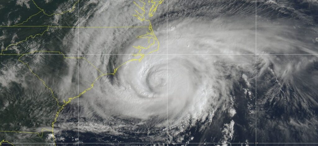
The next few days will be filled with heavy rain for parts of the heavily populated East Coast!
A tropical storm warning has been issued for those along the North Carolina coast to Delaware as the approaching storm could develop into a tropical cyclone. Weather updates come via the National Hurricane Center on Thursday, September 21.
Residents in the storm’s vicinity are advised to prepare for its arrival. The threat is expected to emerge between Friday and Saturday, bringing the danger of high winds and flooding alongside the effects of distant Cyclone Nigel.
How Brewing Tropical Storm Forced East Coast Residents to Cancel Their Weekend Plans
According to AP News, the National Hurricane Center revealed the formation of “Potential Tropical Cyclone Sixteen” following its location about 345 miles (550 kilometers) southeast of Charleston, South Carolina. A 5pm advisory from the center said the storm was heading north at 8 mph (13 kph).
It looks like a tropical storm or hurricane named Ophelia will hit North Carolina. Watch Lumberton NC which is very vulnerable to flooding. Has labeled North Carolina’s most dangerous city for damage & economic damage last hurricane. #Orphelia pic.twitter.com/1Kvl4rlfPb
— JLR© (@JLRINVESTIGATES) September 21, 2023
A potential tropical cyclone, as defined by the hurricane center, is a disturbance that appears within 48 hours while carrying the threat of tropical storm or hurricane conditions. The storm could reach the North Carolina coast around Friday night or early Saturday.
Ahead of its speculated arrival, meteorologist Maria Torres, a public affairs officer with the center based in Miami, advised residents along the Atlantic coast to gather supplies and prepare for the storm in the next 24 to 48 hours. Addressing the severity of the storm, Torres said:
“This will bring some tropical storm force winds and storm surge along with strong winds to the East Coast through the weekend, especially from the Southeast into the Mid-Atlantic states.”
The potential tropical cyclone area is expected to hit from Cape Fear, North Carolina, to Fenwick Island, Delaware. The Chesapeake Bay south of the North Shore, the Potomac Tidal south of Cobb Island, and the Albemarle and Pamlico Sounds have also been issued tropical storm warnings.
Officials from Virginia emergency management stressed that residents should prepare for heavy rain, strong winds, and flooding in the next few days. The danger doesn’t end there as North Carolina Emergency Management revealed that the state’s beaches will experience large waves caused by distant Hurricane Nigel.
NEW: Potential Tropical System #16 set in the Atlantic. The NHC’s preliminary forecast has a 60 mph tropical storm entering North Carolina this weekend, especially Saturday evening. A Tropical Storm Warning is in effect with a potential surge of 2 – 4 feet. The next name is… pic.twitter.com/H0P05eMu0d
— Matt Devitt (@MattDevittWINK) September 21, 2023
Florida & Other East Coast States Warned of ‘Intensifying’ Tropical Storm Lee
Weeks before the news of Potential Tropical Cyclone Sixteen arrived, Florida and other East Coast states were bracing for Tropical Storm Lee. According to the National Hurricane Center, the threat could become a hurricane as its strength has increased with its approach.
“Lee is not far from hurricane strength, and it will likely reach that status later today,” the center’s 5 a.m. update on Sept. 6 read. “While it is too early to determine the location and magnitude of this potential impact, interests in the area should monitor Lee’s progress and further updates to the forecast.”
Reports state that Tropical Storm Lee is expected to pack maximum sustained winds of 65 mph and be located approximately 1,300 miles east-southeast of the northern Leeward Islands. Rapid intensification of storms like Lee occurs “when the storm’s winds intensify rapidly in a short period of time.”
 National Hurricane Center
Scientists define it “as an increase in wind speed of at least 35 mph in 24 hours or less – a phenomenon aided by warm ocean waters.” At the time of the report, sources stressed that if the typhoon remained at sea, “dangerous waves and rip currents could once again threaten the East Coast.”
Categories: Trending
Source: thtrangdai.edu.vn/en/


